Showing posts with label flora. Show all posts

Sunday, May 14, 2023

Colors of Marin Headlands Wildflowers in Sunlight and Shade


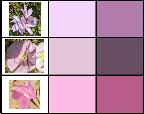
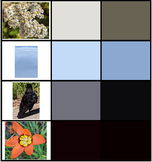
I took a lot of pictures of wildflowers in the Marin Headlands today, then used the good old MS-Paint color picker (eyedropper icon) to pull out a pure color from the petal where it's illuminated by the sun, and a where it's shaded.

I made this because
  1. I am fascinated by attempts to distill things down to their essence.
  2. It's amazing how we think of an object as a single color, and yet objectively it is multiple colors as the light is incident on our retina because of shading, and we still understand it as a single continuous object.
  3. Wildflowers are pretty as hell bro.
I'm very much an amateur so if any of these are misidentified, I appreciate your correction in the comments. Also if you find the colors interesting please take them for your own purposes.

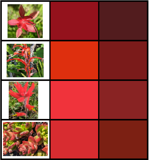
This is the full "spectrum" of colors I sampled shrunk down to see all at once.


The first three reds are Indian paintbrush species. There are 20+ species of Indian paintbrush and their ranges overlap significantly, so if you can distinguish and identify the paintbrush species, thanks in advance for doing so in the comments. The last one is live forever, an endangered Dudleya succulent species whose red leaftips are much more brilliant when "purified" by this sampling method. Protect our coastal succulents - they're targets of criminals that are digging them up on masse and destroying them (seriously, read that, it's unbelievable.) Also saw some Dudleya on the trail, which has red-tipped leaves (impressively red when directly sampled.)


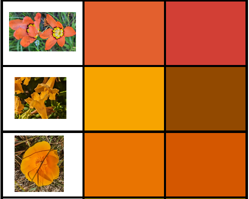
The top orange one is a harlequin flower (sparaxis), a South African invasive, then sticky monkey flower, and finally you damn well better know our state flower.


Respectively, again the (center of the) harlequin flower, field chickweed, the yellow part of the Ferdinand iris petal, French broom (invasive - die), goldenfields, and blue-eyed grass (the second stupidest flower name in this post.) Centers of flowers are often yellow, I wonder why. Then again, we're probably missing the important part of the story - flowers are "designed" for bees who can see into the UV.
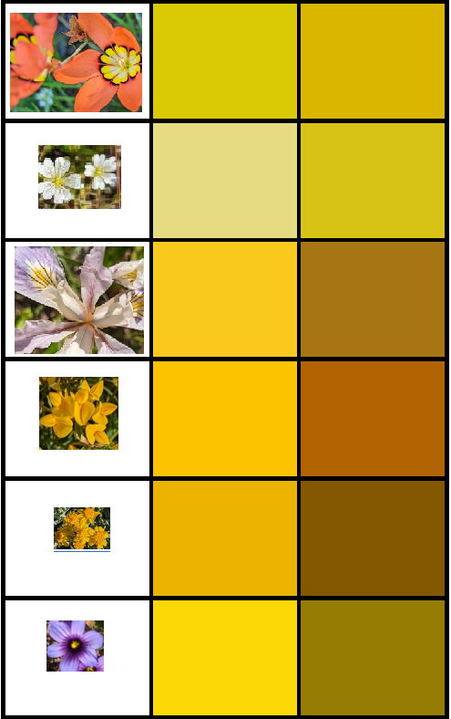


A nice green leaf, and then the stem of the goldenfields (a more minty green like sage) and the green part of the liver forever - again, amazingly yellower than it seems when seen in situ.


Hound's tongue (one of my favorite despite having the stupidest name ever - maybe they're hallucinogenic when ingested or something), then the sky just above the fog and then immediately overhead, and finallly ceanothus.
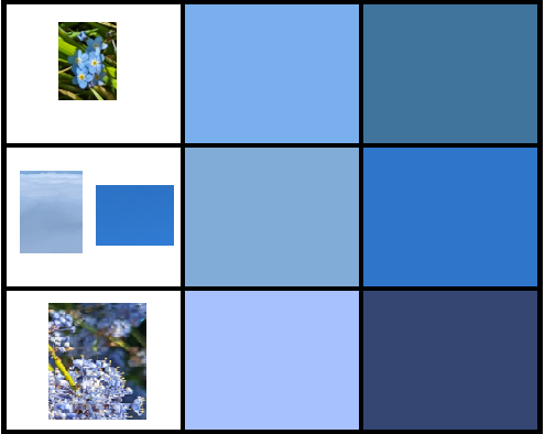


Lupine (my favorite, which smelled amazing in this warm day - I used to say they smell like mothballs, but they're actually awesome and much less purple and more blue when purified), blue eyed grass, and again Ferdinand's iris.


Pink is not a real color on the spectrum, but we'll pretend. Checkerbloom (I think), white bindweed, and checkerbloom again.


For white, yarrow, then the sky both in the fog and above it (in situ, seems gray, not blue). Then for black, I was wondering where I would get it from, and had resigned myself to just using the tiny black rim of the harlequin flower, but then as if reading my mind this fellow helpfully landed right in front of me near the trailhead and started cooperatively strutting back and forth. I happen to be fascinated with ravens and the Pacific Northwest art tradition around them.


FIN


Sunday, July 5, 2020

Willow Creek Preserve, Pacific Union College Forest, and Sept 27-69 - 6:30. by knife

First, and let me be very clear about this, Han Bul is a better restaurant than Soban. If you disagree then I guess you don't really understand authentic Korean food. This means you SS. ZING, HEY-O! (rimshot) (In all seriousness everyone, it's not yet safe to sit in a restaurant - but do support them. Consider getting takeout, or getting a gift card that you redeem later.)

First I stumbled on Willow Creek Preserve by noticing some trails marked on Google Maps that were outside of the (also awesome) Pomo Canyon. I noticed cars parked in a trailhead-like way along Coleman Valley Road and I KNEW you guys were holding out on me, and sure enough I found it.


I'm always struck by the convergent evolution of sorrel and clover, at least in terms of gross anatomy. The former is in the buckwheat family, the latter in the pea family. Per Timetree, their most recent common ancestor was likely 117 million years ago. (For comparison, humans and whales diverged only 96 million years ago.) Sorrel does not fix nitrogen like clover (I assumed there was a symbiosis) but does have a nifty rapid (fast enough to see it move) closure response to direct sunlight, which it's not used to, growing in redwood forests as it does. It's obvious enough why sharks, whales and mosasaurs would evolve convergently, but redwood sorrel is found in the deep shade of redwood forests and clovers in open fields, so this remains a mystery for some keen-minded botanist to solve.

Then I had a little of the ol' patello-femoral recently from a minor acute injury going up stupid Collier Springs Trail in Marin County Watershed land, but still major enough that I don't want to exacerbate it. Was thinking of going up to Wright Peak at Clear Lake, but considering the trail is described as steep and loose, exactly the kind of terrain that caused the injury in the first place, I decided to check out Las Posadas State Forest. Well that's closed. BUT immediately adjacent, I stumbled across the quite-awesome Pacific Union College Forest, popular with bikers, through which the Bay Ridge Trail runs. Even on a holiday weekend-Friday it was still fairly light. It's amazing that I'd never even heard of this place a 45-minute drive from home and it's pretty sweet.


It's interesting to see how each valley over gets progressively drier (Santa Rosa plain, then Sonoma, then Napa, then Pope/Berryessa.) The redwoods and Douglas first more or less stop on the west side of Napa, the east side of Napa looks drier than the west, and once you've over that (into Pope and Berryessa Valley) it's mostly chaparral and a few ponderosa pines and much of it, especially the Blue Ridge on the east side (i.e., the last ridge before the Central Valley) the often eroded-looking dry sandy scrub could pass for SoCal.


After that I gave into my morbid side and found the island (above) where one of the Zodiac Killer's attacks happened. After the dry Mediterranean summer, peninsulas emerge connecting these islands to the shore, as was the case in September of 1969. To take away the fun of figuring it out on your own - it's on the west side of the lake, at the south end of the Oak Shores Day Use Area, near the Lake Berryessa Field Office; nearest mile marker 6.75 along Berryessa-Knoxville Road. It turns out the victims were PUC students as well (I'd never heard of PUC until I ran in their forest mere hours before.) Helpfully, the killer called the sheriff's office that night though boaters had already heard the victims' cries for help (they did not immediately perish) and to further clarify, the killer wrote in marker on the couple's car door "Vallejo 12-20-68, 7-4-69, Sept 27-69 - 6:30. by knife". I've visited the first two locations as well and barely remember what they look like - this one leaves much more of an impression.

Thursday, April 2, 2020

East Coast: Where the Trees Don't Lose Their Leaves

I've always wondered where the leaves stay green throughout the year - on the East Coast. Why does this matter? West Coast natives will never understand this, how the combination of the East Coast mentality and continental climate can make you feel trapped by the climate. During a road trip from Philly to Florida at spring break one year, the sun came up right about as we were crossing from South Carolina into Georgia, and seeing the green forest around us, I felt like we'd escaped - like we had cheated the world. It's not even the temperature that can be grueling about a temperate zone winter - it's the colorlessness, the gray clouds and especially the brown trees. A friend from Georgia referred to the Pennsylvania winter's wan sun, clouds and dead trees as the Dead Land. I had the same experience when I moved to California, and drove across the country in December as I descended the Sierras and came into the foothills and Sacramento's eastern suburbs, again there was green. Again I felt like I had come back to life, and I was home.

So I had always wondered: where do the trees stay green?

I started to think I was going to have to learn to program somewhat, and find satellite images from August and February of the East Coast, and then (if I was being rigorous) look at the color value of each pixel and try to correlate that with vegetation. But these maps are already available. (I couldn't find them the last time I did this search.) The first map is from databasin.org. Although weather moves west to east (hence the East Coast being much less moderate), there is still an under-emphasized maritime moderation effect near the coast - for example, the robins don't migrate for the winter in suburban Philadelphia, but one county away in Berks, they do (they come back early February though.) So this map shows how the coastal deciduous zone ends right near the Virginia-North Carolina line, and then hugs the coast, a bit downhill of the Fall Line, maybe 100 miles from the ocean. The pattern continues as it bends around the Gulf Coast, trends a bit north in Louisiana, and then much to my surprise, bends back toward the coast to include Houston. West of that, the mountains and/or dryness of the climate dictate vegetation more than temperature. I can confirm - having flown into Houston at Christmas, I was quite surprised that the trees were brown. (Corpus Christi was still green.) What surprises me most is I think I expected the 40th parallel to dominate more over coastal effects (as the typical dividing line between temperate and subtropical) but this is not the case.

And speaking of the southeast - while you're social-distancing, don't all hike on the same trails! It happened in both California and now Georgia. Come on outdoorsy types. We're smarter than this. And I want more of us to stay alive!


It also confirms what I suspected about Virginia: it's really just Pennsylvania with nastier summers.

Below is a map of the Fall Line from gallivance.net, where the first hills begin. There's nothing like this on the West Coast, where instead of being a passive margin where the land just kind of "gives up" to the ocean, the mountains come right up to the water, sometimes a mile high within a few miles as in California's Central Coast. The Fall Line corresponds to agricultural development historically, the Black Belt, and where the mills were. Almost all of Pennsylvania is uphill from the Fall Line - it's already at the Falls Bridge/Schuylkill Aqueduct, and the Twin Bridges (ie, Roosevelt Boulevard - before Manayunk even!), which is why large vessels don't go upriver past Philly. (Imagine a parallel universe where they dock in Reading. With cruise ships as carriers of disease - norovirus for many years and now COVID-19 - that's probably a good thing.)


Above: from Wiki, the Falls Bridge, aka the Reading Railroad Bridge, and the Twin Bridges at the Fall Line on the Schuylkill in Philly. Below, a typical cruise ship (from Signal Horizon.)


Of course a lot of the non-deciduous forest in the Carolinas is pine forest. This map shows that the vegetation you'll see along I-95 heading south transitions from Loblolly pine to mangroves along the river and patches of chestnut oak.


Thursday, April 28, 2011

Poison Oak - Different Species in Sierras and Coast?

[Added later. Says Dan Simpson from Dan's Hiking pages: "A single species of poison oak (Toxicodendron diversilobum) can take on variety of appearances...part of its malevolence!"]

Ever noticed that poison oak in the Sierras doesn't look like the poison oak along the coast? It doesn't. I've long thought about this and today a link in Sequoia NP's Twitter feed prompted me to post this comparison:


Sierra poison oak at top, coastal on the bottom (images from NPS photo site and Yoga Slackers resp.) Different, huh? Though it's not to scale, you can tell how the Sierra variant has larger leaves that are much less rounded, much more like their namesake oak leaves. Coastal P.O. is really just small bumpy ovals. This difference may be relevant. Why? For one thing, do the oils from each necessarily induce cross-reactions? Is one worse than the other? It's possible they're the same species, but they look different when grown in cooler, more extreme seasonal conditions - or that there's an actual genetic difference, and we're looking at different species or subspecies that have long been incorrectly classified. I hate poison oak with the obvious motivation of personal experience, so if I can spare one other person (maybe you!) the nightmare of contact dermatitis, I'll be happy.

Note that the Sequoia NP folks said it's found up to 5,000' elevation. Up in the Bay Area we usually assume a cut-off of 4,000', and then further north, somewhere between Portland and Seattle the grow-line drops to sea level and you don't see it anymore. It also survives just fine in the desert (I've seen it in the Mojave) as long as it can grow in a shaded canyon near a water source.

I was surprised not to find any literature on these variants, but what's both frustrating and exciting is that you can't assume someone has properly studied plants like this. That's how it often goes: common organisms described centuries ago, if they don't cause disease or have an economic impact, don't get grant money dedicated to them. Consequently there are basic discoveries waiting under our noses even though we think science has already swept out all this space. So what's going on, West Coast naturalists? Help us out!

I should add that further confusing the nomenclature, a) other western states (non-coastal ones) use the term "poison ivy" for what appears to be the same plant as "Sierra poison oak", and b) true poison ivy (Toxicodendron radicans) and poison oak do in fact overlap in their ranges - I have encountered this in Austin, Texas as well as Moab, Utah. Sure, as a rule it makes sense not to touch plants with the word "poison" in the name, but it seems clear that we still have a lot to learn about the plants literally growing in our back yards.