Showing posts with label bay area. Show all posts

Sunday, May 14, 2023

Colors of Marin Headlands Wildflowers in Sunlight and Shade


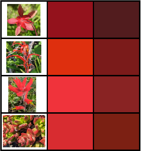
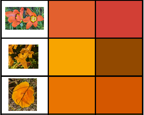
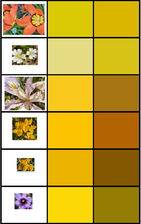
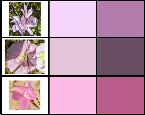
I took a lot of pictures of wildflowers in the Marin Headlands today, then used the good old MS-Paint color picker (eyedropper icon) to pull out a pure color from the petal where it's illuminated by the sun, and a where it's shaded.

I made this because
  1. I am fascinated by attempts to distill things down to their essence.
  2. It's amazing how we think of an object as a single color, and yet objectively it is multiple colors as the light is incident on our retina because of shading, and we still understand it as a single continuous object.
  3. Wildflowers are pretty as hell bro.
I'm very much an amateur so if any of these are misidentified, I appreciate your correction in the comments. Also if you find the colors interesting please take them for your own purposes.

This is the full "spectrum" of colors I sampled shrunk down to see all at once.


The first three reds are Indian paintbrush species. There are 20+ species of Indian paintbrush and their ranges overlap significantly, so if you can distinguish and identify the paintbrush species, thanks in advance for doing so in the comments. The last one is live forever, an endangered Dudleya succulent species whose red leaftips are much more brilliant when "purified" by this sampling method. Protect our coastal succulents - they're targets of criminals that are digging them up on masse and destroying them (seriously, read that, it's unbelievable.) Also saw some Dudleya on the trail, which has red-tipped leaves (impressively red when directly sampled.)


The top orange one is a harlequin flower (sparaxis), a South African invasive, then sticky monkey flower, and finally you damn well better know our state flower.


Respectively, again the (center of the) harlequin flower, field chickweed, the yellow part of the Ferdinand iris petal, French broom (invasive - die), goldenfields, and blue-eyed grass (the second stupidest flower name in this post.) Centers of flowers are often yellow, I wonder why. Then again, we're probably missing the important part of the story - flowers are "designed" for bees who can see into the UV.


A nice green leaf, and then the stem of the goldenfields (a more minty green like sage) and the green part of the liver forever - again, amazingly yellower than it seems when seen in situ.


Hound's tongue (one of my favorite despite having the stupidest name ever - maybe they're hallucinogenic when ingested or something), then the sky just above the fog and then immediately overhead, and finallly ceanothus.
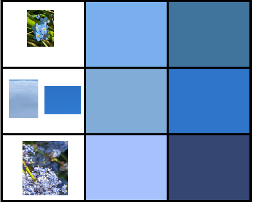


Lupine (my favorite, which smelled amazing in this warm day - I used to say they smell like mothballs, but they're actually awesome and much less purple and more blue when purified), blue eyed grass, and again Ferdinand's iris.


Pink is not a real color on the spectrum, but we'll pretend. Checkerbloom (I think), white bindweed, and checkerbloom again.


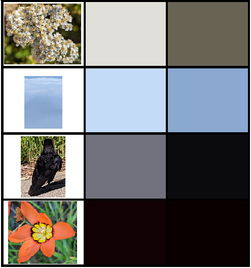
For white, yarrow, then the sky both in the fog and above it (in situ, seems gray, not blue). Then for black, I was wondering where I would get it from, and had resigned myself to just using the tiny black rim of the harlequin flower, but then as if reading my mind this fellow helpfully landed right in front of me near the trailhead and started cooperatively strutting back and forth. I happen to be fascinated with ravens and the Pacific Northwest art tradition around them.


FIN


Wednesday, July 17, 2019

Pics from Around the North Bay: The First Month


Above: from Point Reyes, solitude and foxglove along Estero trail on the way to Sunset Beach. The orange stuff in the first image is dodder, a parasitic plant which I notice a lot more in Socal (esp. around San Diego.) The area around the Estero always feels so empty and lonely in a way I find strangely comforting; it reminds me of Pennsylvania on a nice October day, or maybe Ireland in the summer. Below: this colorful fellow is a garter snake in Point Reyes. Nearby I also saw a 3 foot leopard shark swimming around under a trail bridge at the tip of one of the fingers of Drake's Estero, but the pictures didn't come out well. Below that: a gopher at the trailhead.


Above: starfish in tidepools along the Sonoma Coast. Check out Kortum Trail which runs through the moors along the coast and in particular the mammoth tusk-markings nearby.) I just saw my first (in the wild) sea otters here.

The next few are from Lake Sonoma: as it were, the Blue Marsh of Sonoma County. I had never been here before and I'm glad I finally got there - great views, although despite what the Sonoma 50 website will tell you, "rolling" is a stretch for these hills. Also hot in the summer - I think this will be a fall through spring location for me.


Above: now what kind of an attitude is that mister. Below: real mature guys. You can't just go naming trails after poopoo!


Above and below: Taylor Mountain, in the woods, and then with Mt. St. Helena looming. And then a tower of bicycles.


Above, pastoral charm outside Petaluma, which was on my route to connect my house to the loop around the Bay (and therefore to the state line.) Below, Salmon Creek Beach: clouds and the mouth of the Creek. These really looked like the pictures of morning glory clouds over the Gulf of Carpinteria. But these are much colder. On that note, Norcal beaches are like models you hire for parties. They're stunning, and you're drawn to them, but when you get there you realize they're just for looking at. Plus you get eaten. (Note: all I searched for was "sonoma coast shark attack" and found an incident at that exact beach from 2 months ago that isn't even a point of discussion among locals.)


Last three above: I somehow forgot how awesome Marin Reservoir territory is. The change in landscape on the single track trails from Deer Park past Phoenix Lake is pretty startling (open oak meadow to redwood.) Below: Annadel State Park, looking east toward Hood, then north toward Mt. St. Helena, and Lake Ilsanjo


Apparently, so I'm told, definitely not from firsthand experience, in Annadel if you follow Rhyolite over the edge of the old quarry and descend, you come out on Woodley Place. You can also see redwoods which survived the 2017 fires sprouting needles even on the trunk, which I've only seen once before, at the southern end of the redwoods' range in northern Los Padres. They look furry. It's also obvious that multiple small fires started in these woods and then burned themselves out, since you pass through 1-2 acre burn-areas out in the middle of things that obviously weren't being guarded by firefighters.


Above: Sonoma sunsets. Below: the last Sacramento sunset, and then a Sonoma moon. When I first saw a moonshadow as a kid I was just amazed.


Below, Hood Mountain. Still lots of fire damage, but life is finding a way. From the top you can just barely make out San Francisco in the distance. This mountain has the advantage of having a good winery immediately at its base.


And then back in the Sierras, Stephens Trail and Tahoe. My hiking companion is from the future and if you see his face you'll get all screwed up. Last weekend in June, it was still too snowy to do a full leg of the Tahoe Rim Trail. Don't trust this snow map which said everything was clear.