For going on two decades I've been a Californian, but I emerged into this world in old Berks. And when you move, you change quickly. First the leafless winter forests start to look shockingly barren, and then people start to sound (and think) funny, and then it just doesn't feel like you belong there anymore. But since I've grown into my foreignness, I've been able to see Berks with new eyes, and I now really enjoy visiting as a tourist. The almost tropical green canopy of a Pennsylvania forest in summer, the dusting of snow around an old stone house, windows glowing warmly next to a stubbled field - these are things you don't see in California. I can also appreciate as well that Pennsylvania is one of the most culturally and historically unique parts of this country, but of course both visitors and residents of Berks might point out that cultural uniqueness doesn't give you anything to do - it's not an event. I kind of did convert culture into an event last year by literally stumbling across John Updike's grave in Plowville last year, although I'll grant that grave-stumbling is not something you can plan.
So without further ado, here's my list, which is just as much to advertise Berks as it is for me to revisit when I'm back home. (If you want the full on promotional experience, you can go to visitpaamericana.com, which is actually a pretty good resource.)
CREATORS:[Added later, why didn't I think of this before?] writer John Updike, artist Keith Haring, and musician Taylor Swift (or is that "musician"? depending on your taste).
PROXIMITY TO NATURE AND THE URBAN NORTHEAST: it's cliche, but in Berks you're close to many other things, without paying big city prices. There are not a lot of other places in the country that can say this. In particular, do NOT underrate the opportunities in the Appalachians - the Appalachian Trail, Glen Onoko Falls (and here are my photos), Ricketts Glenn, and a million other forests and parks and gamelands. Do you ever get up to State College? Do you get out on the mountain trails every time? Why not!?? (When I was in college I did, and I still don't think I did it enough.) A friend from California who spent his childhood summers in Yosemite said that he thinks the Delaware Water Gap is the prettiest place he's ever been (it sure has more bald eagles than Yosemite). And of course there are day trips to New York and DC and the shore in the summer. (I kick myself for not going to New York, Philly and DC more before I moved away.)
BERKS OUTDOORS: good in ANY season. The way I used to think, winter put a stop to any outdoor activities. But if you live in the West (including California) it's just a time to do a whole other set of activities. Get those boots on, the silence and purity of a winter hike is amazing!
- Blue Marsh and Tulpehocken Trail - every time I'm home I'm just amazed how pretty this lake is (and since I ran around the whole thing I'm something of an authority on the matter.) And in the summer, the Rock in Hamburg may be closed, but the Cliff in Bernville is not. Of course there's an ultramarathon if you want to do it all at once and have people hand you water along the way. (Actually a lot of good races like this in the area.) Also remember Gring's Mill and the Canal Museum!
- Mt. Neversink - cool trails from near 422. Looking down at the Schuylkill there it almost reminds me of parts of Oregon; the view actually makes it feel isolated.
- French Creek - an oddly under-discussed park, and there is more and more land connecting to it, making the contiguous conserved area much bigger, i.e. Hopewell Woods, and now Gibraltar Hill, which is now open. (Views from the top are excellent.) Also odd in that these low hills are so steep - at one time they were probably the highest mountains on Earth, hundreds of millions of years ago. True story, French Creek is the only place I've heard an extended first-language conversation in Pennsylvania Dutch.
- Nolde Forest - as a kid I used to think it only served the function of lame destination for field trips, but I really enjoy running there now. After all, one New York Marathon winner trained there...
- Schuylkill River Trail - already pretty cool, with signage from Hamburg down to Reading, and then with rare exception connected all the way to Philly (and already connects almost continuously from Philly up to Pottstown.) Needless to say I'm going to be through-running this whole thing too.
- Pretty drives - I spent my teen years driving around the back roads of Green Hills and often comment that Napa is the closest thing California has in terms of rural scenery. And that Fleetwood-Lyons/State/Main/Weis road parallel to 222 up in the northern part of the county is also very pretty.
HISTORY: there are preserved canals (in Gibraltar and Wyomissing), and Routes 724 and 10 were both already used as wagon paths in the mid 1700s. Route 61 was used as a footpath by Unami-speakers for who knows how many centuries!
- The AME church in Reading - not only the sixth AME church in the U.S., but a place used to smuggle slaves on the underground railroad, with the preserved underground chamber still viewable. The late Frank Gilyard was kind enough to give me a tour.
- Homesteads - Conrad Weiser, Daniel Boone, Morlatton (oldest building in Berks), Hopewell, and nearby Ephrata.
FOOD: first, it must be said, there really is nothing like Wawa, or for that matter Sheetz, anywhere else in the country. Berks has great Italian and PA Dutch food and I've found some fun night life too. And in a half hour you're in Lancaster with all the smorgasbords, buggies and shoofly pies you could ask.
- Mom Chaffee's in West Reading - great Italian
- Mangia in Mohnton - get the cheese wheel (thanks Dan)
- Chatty Monk and Winedown - is it just me, or did Penn Avenue in West Reading get a lot more interesting in the last ten years? Vertigo Records was a fun find too.
- Hong Thanh - in the Weis plaza in Spring Township, one of my favorite Vietnamese places anywhere, even including the West Coast.
- Beer - Goggle Works has the best beer selection of any place I've been in Berks (although if you're reading this and know of more, I'd be happy to be proven wrong). And Stoudt's brewery is just down in Adamstown.
- Ridgewood Winery - I haven't yet been but I love that there's a winery right there.
- Mike's Tavern near CarTech - the crowd is one of the more interesting mixes I've seen in a while, I'll be getting in there when I can.
The usual nonsense. (Lots of stuff just in Berks County outside of Philly, go here for a list.)
PHILLY
We hit Pat's Steaks the night we landed, but I'm still a Jim's guy. On the way into the hinterlands I visited the oldest building in Berks County, built by Swedes who had ventured up the Schuylkill to build the first stone structure (Morlatton House ca. 1716), three decades after William Penn's ride up the icebound river to negotiate with the locals. Daniel Boone would be born not quite 20 years later a couple miles further up the road. My inevitable surprise in Berks County though is Blue Marsh, whose prettiness somehow still shocks me. Also, I"m now so old that I an't remember how to find the Cliff without looking online. I did a very nice 6-miler just from the Cliff to the Heidelberg Bridge in Bernsville, and needless to say I can't just enjoy it for what it is so next time I have to run around the thing.
Above: online map courtesy Blues Cruise Ultra. Below: Blue Marsh and trails.
STATE COLLEGE AND CENTRAL PENNSYLVANIA
I wasn't nearly the trail maniac in college that I am today and regret that I didn't spend more time exploring Central PA (Allegheny National Forest for one thing.) It was fun getting to State College but it's been long enough that I'm quite ambivalent about these visits and in truth I'm not even nostalgic anymore, since PSU doesn't feel like it's "mine". I knew this was very likely my last visit and it was a nice swansong. I got into the Rathskeller for a beer in honor of my dad. I foolishly didn't drink in college so, oddly enough for an old alum saying goodbye, this college staple was actually a novel experience for me. (Worry not dear reader, I stopped that nonsense and now I drink quite heavily.)
After the obligatory crowded post-game-day hike up Mt. Nittany, we headed down to the area between Huntingdon and Mt. Union to bag the Thousand Steps. Also very busy! A part of the nifty Standing Stone Trail, I've had this one on my bucket list for a while. I recently became obsessed with the Allegheny Front and Plateau, and noted how north of the PA Turnpike, the escarpment gets steeper as it ascends rather than rounding off as the ridges to the east do. The boundary between Alleghenies and Ridge-and-Valley in PA is also the watershed boundary between the Atlantic and Gulf of Mexico. There is very little conserved land right along the front and this is a fascinating and unique area of Pennsylvania and the Northeast generally.
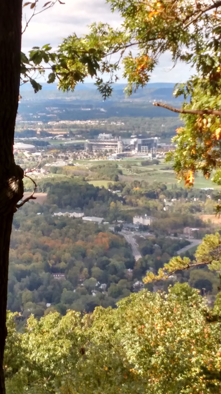
Above and below: view from Mt. Nittany; second is zoomed on Beaver Stadium. I never learned if it was really true that every seat facing Mt. Nittany had to be able to see it. (By the way, did you know they already had the Nittany Lion in Tang dynasty China? See if you can find it in the photos here.)
Above: hey THANKS. Below: view from the top of the Thousand Steps.
Above: you don't have to be a geologist to see the Allegheny-Ridge and Valley boundary here. The Turnpike climbs onto the Plateau between Bedford and Somerset, fittingly enough where you pass through the Allegheny Tunnel. The Flight 93 site is nearby (already been) and there's a cave in nearby Mann's Choice with coral fossils from the Paleozoic but dammit it's privately owned and hardly ever open.
Above: the Allegheny Front (in red) is also the boundary for central PA dialects, not unexpected as people's travel would historically be impeded there, and the differing geology has probably led to different economic activity. Nice illustration of the principle that geological barriers obstruct both gene and meme flow. Below: another box checked: view from the top of Mt. Davis, the highest point in Pennsyvania, at 3,213'. Yes, lower than Foresthill. But still neat and felt very plateau-y.
SOUTHWEST PENNSYLVANIA
Another point! The PA-MD-WV tripoint! I'd previously seen Fort Necessity (where young George Washington learned the value of guerilla warfare from the French), Wright's Fallingwater, and Ohiopyle rapids, and my travel companion was satisfied merely hearing the eloquent orations I delivered on these and many other topics during the drive. Unknown to me until this visit: a few miles from Fallingwater is Kentuck Knob, another Wright home. (And very unpatriotic of me to say, I saw a restored Qing Dynasty official's home in Chengdu, Sichuan, China, that I thought was much cooler than Fallingwater; scroll down here for some pics.) For a while I have been scheming to run up Mt. Summit, the face of Chestnut Ridge, the very last of the Allegheny-Appalachian system as one heads from the East Coast into the Midwest - but there is no safe way to do it. Yes, the local club holds a race once a year where (I verified) they run up the highway - not safe! - and there's a road that comes up the back way right past where Washington (or his native ally) killed the French officer Jumonville that sparked the Seven Years War (or the true first world war, depending who you ask). Either way, also not safe.
Above: your blogger at the tripoint. In the background are West Virginia border guards, who scrutinized our entry papers closely, and then ate them. Below: Mt. Summit Hotel at the top of Chestnut Ridge, the edge of the Alleghenies, looking west over the start of the plains. Washington's French-killing spot is about three miles from here.
Above: supposedly the steepest street in the U.S., Canton Avenue. Below: to the extent that the Whiskey Rebellion had a headquarters, this was it. George Washington just could not stay out of Western Pennsylvania to save his life.
Above: Pittsburgh and the start of the Ohio River. Note the sediment coming from the Monongahela. Below: looking down the Duquesne Incline tracks back toward the river. Again you can see the sediment boundary from the Mon River.
Other silly PA projects for the future:
- Laurel Highlands Trail
- Standing Stone Trail (Thousand Steps is part of it)
- Ascent of the Allegheny Front (route 30)
- PA-MD-DE tripoint (the only other one in PA that's not underwater)
I crossed California on foot. Mostly running, sometimes hiking, a conservatively estimated 328 miles.
DISCLAIMER: this whole thing was dumb and in the course of it I was killed repeatedly by bears, passing trucks, and jealous husbands. If you run on these remote trails and busy roads, you are assuming all risks, will definitely be killed, and are dumb.
Why would someone do this? Partly as a deliberate effort to keep running interesting - but why this specific project? Probably two reasons. First, I have a weird fetish for connecting things. Second, I like experiencing different kinds of trails, and seeing (and surviving) ecosystems in different places. Unsurprisingly, it's never enough, but there's still something special about watching the flora around you change as you move away from the coast and up into the mountains. N.B., this is not in the order I did them. I had already run the part from the Golden Gate to Benicia in the course of my Loop Around the Bay, so you can read about that in a separate post. I would like to take this opportunity to castigate a particular swarthy gentleman for corrupting me wife at the celebration after I reached Benicia. For the sake of narrative coherence the post starts in Benicia, going toward Nevada[1].
Above: in mid-March we were coming back from our honeymoon in China, to the last hurrah of 2 solid weeks of El Nino rain in California. The morning we landed was the first sunny day in the Bay after all that precipitation, and when I looked out past the Golden Gate, I saw the divider between silty fresh water pushing out into the Pacific, and the Pacific saltwater. It's a neat feeling to know you've run the entire length of those rivers coming down from the Sierra Crest.
From Benicia to the American-Sacramento River Confluence, Sacramento
Boy is that Central Valley wide. Not my favorite set of runs I've ever done, but in any project where you have to connect A to B through actual real space, on foot, you end up in some places you wouldn't have seen otherwise. Plus I did a lot of it in springtime and it kinda sorta reminded of Lancaster County, PA. From the Benicia pier, the route goes on surface streets and 2nd Avenue (not super safe) to the Lake Herman parking area (where the Zodiac Killer offed some folks.) From there, I ran along the also not-super-safe access road on the west side of 680 that goes to Fairfield. In Fairfield I ran along surface streets. Here I discovered a couple interesting things: an urban trail that slices diagonally through Fairfield, as well as Heretic Brewing, which I highly recommend. There was one really stupid limited-access road I ran on in Fairfield that I'm not even naming because of how dangerous it was to do this. Fairfield is not my favorite town I've ever been in; sorry to say there's something about big military bases in the U.S. that brings something of the Third World into the areas surrounding them. At least I was able to enjoy a gourmet meal at a well-known Michelin Star restaurant in the area.
680 sunset on windy spring night, between Benicia and Fairfield
From Fairfield I went north on Peabody Road past the prison into Vacaville where I turned onto the Alamo Creek Bike Trail, which was another pleasant surprise from this little project. The bike trail comes out near Elmira and Leisure Town Road (the east edge of development in Vacaville), and then I ran further north on Leisure Town, to where there are multiple canals with roads on them. Be careful not to trespass here.
Above: typical view as I ran west across the Central Valley. I was actually heading west from Sac to the coast at this point and those coastal mountains got bigger very, very slowly. (Gmaps street view)
I then went up Byrnes, Weber, Lewis and Midway to the National Cemetery (did you know this was there? Me neither. Very nice place; you can see their large flag south of the 80 between Vacaville and Dixon.) From there, I ran along Midway and Porter to Dixon. East of the cemetery on Midway there is an Osage orange tree, very out of place in California (brought on a vehicle visiting from the Southeast, carrying family to see the memorial of a fallen loved one?) This section was one of the most unpleasant and dangerous of the run, although Dixon is a cute little town. From Dixon, I got to Davis via Dixon Avenue, Pedrick, Vaughn, Runge, Tremont, and Old Davis Road, crossing under 80 and arriving at the campus, which has a nice little river trail with redwoods. From campus, parallel to the 80 until I was at the eastern edge of Davis, and then onto Road 32A and finally onto the protected bike path that runs along the north side of the 80 into West Sac (I didn't know this was there until figuring out the route for this project). I did not feel totally safe running through West Sac along West Capitol, even during the day. From there it was across the Tower Bridge into Sac, and along the river trail behind Old Town and Jiboom Street to the river confluence.
American River Trail - Confluence, Sacramento to Beal's Point, Lake Folsom
Typical scrub oak forest along the American River, Mississippi Bar.
If you want detailed description for this section you can just look at the map of the ART for the American River Trail. Here's my post on it when I completed it. Some highlights and lowlights: the river confluence peninsula at Discovery Park has an enormous amount of skunks as well as feral cats, probably because someone is feeding the cats, and the skunks get some of the action. The trail does have a bit of an insecure feeling (i.e., itinerants) until you get to about the Guy West pedestrian bridge at Sac State. The amount of wildlife I saw on this trail, even as close to the city as Sac State, is impressive - coyotes, turkeys, deer, and rattlesnakes make regular appearances. (Seen a rattlesnake? Add it to the encounter tracking map here.) I've even seen beavers a few times (no that's not a euphemism) and seals have been seen as far as William Pond Pond - which is a really nice spot. The hills and bluffs begin in earnest along Lake Natomas, and next thing you know you're at Beal's Point, Lake Folsom.
The Pioneer Trail - End of the American River Trail to the Start Western States Trail (Folsom to Auburn Along the North Fork)
This segment had maybe the best surprises (for me anyway) of this whole project. Most of this mileage is along the Pioneer Trail. From here on up, many of the routes did not correspond well to Google Maps, or indeed any map I could find online. I ran from Beal's Point through a nice scrub oak forest to Granite Beach, and then a very low Lake Folsom allowed a more direct route which ultimately linked up with a trail to Rattlesnake Bar. I found these stretches surprisingly empty of people. The section of Pioneer Trail from Rattlesnake Bar to China Bar is absolutely gorgeous and is a fantastic autumn run - not to mention it has wild grapes. From there, up Cardiac Hill and along the canal, to Auburn High School.
Pioneer Trail between Auburn and Folsom in autumn.
Western States Trail
You know it, you love it. I basically did it in reverse, uphill, because why not. I had no desire to attempt this all at once as many outstanding athletes do every year.
Do NOT assume that Google Maps/Western States/etc. are right or that they will agree! And if you're doing these by yourself, then once you're further uphill/out into the wilderness than Foresthill, and ESPECIALLY further out than Swinging Bridge, you really need to know the trails and plan your route, preferably with GPS. (I'm old school and tried to go without, but after one scare my wife finally made me get one. It's worth it.) Don't think you're safe from bears at Training Hill or Quarry just because you're close to Auburn - I saw a bear at the far end of the Foresthill Bridge in broad daylight. There are mammoth bones in the old quarry cave on this trail, hence the name of Mammoth Bar (and a much more pleasant name than Murderer's Bar which is just down river). I can see how people get lost between Green Gate and the Quarry (permanent markings not great), or even Quarry to No Hands. I think Green Gate isn't green anymore. I waited until late in the season to cross at Rucky Chucky (late August); no more than waist-deep at that point. Foresthill to Rucky Chucky is sort of a mandatory 16 mile stretch since there's no access, but it's be-a-U-tiful in the spring.
Above: looking downstream from No Hands Bridge.
Above: sunrise from the top of Training Hill.
Above: typical stretch through the area between the quarry and Rucky Chucky. Not surprisingly, good mountain lion country here.
Above: the long no-access section between Foresthill and Rucky Chucky. Below: what are all those red clumps? I won't give the exact location so you'll just have to get out there and explore the trail for yourself.
I saw a bear between Michigan Bluff and Foresthill, and another one (the biggest black bear of my life) about a mile from Devil's Thumb toward El Dorado Creek. I did the Devil's Thumb to Last Chance section (i.e. Swinging Bridge Canyon), the Sunday of the WS100 weekend, and it was in the 90s even up there, and damn was that miserable on the way back up to Devil's Thumb). Beyond about Devil's Thumb, the time of year you're running becomes a major issue because Mosquito Ridge Road closes (and I think so does upper Foresthill), with good reason, snow! Maps and trails very difficult from Dusty Corners to Miller's Defeat; I got so frustrated I almost quit the project at this point. Duncan Peak still had too much snow at Memorial Day this year to drive through in an SUV. From Duncan Peak you can see the back of the Escarpment, which was very encouraging.
Above: I had finally sighted the Escarpment, from the back (Duncan Peak Lookout).
I found Red Star Ridge to Robinson Flat to be a pain in the a** both in terms of driving there, as well as the run itself - markings on trail really not great, and more confusing the closer you get to Robinson Flat. Saw a bear there too. Duncan Creek is one of the more beautiful mountain streams in this part of the Sierras. I ran Red Star Ridge to Squaw Valley which was my favorite segment - also difficult, with a beautiful hanging valley/box canyon and waterfall below the trail, and the climb up the back side of Squaw seemed like it would never end. (Thanks to wife for driving Soda Springs Road from Red Star Ridge to the 80 and still beating me to Squaw.)
Above: Memorial Day weekend snow was still a problem starting about 6,500'-7000', as seen here on Duncan Peak. SUV didn't help. Big pickups were getting stuck.
Above: the Escarpment with French Meadows Lake in the foreground.
Above: there is a lot of obvious evidence of relatively recent volcanism around Red Star Ridge (including basalt as you see here, but also yellow and red bake zones.) This offends my tidy, hence simplistic sense of Sierra geology. The Sierras are made of metamorphic rock dammit! Why didn't the tectonic plate read the textbook!?!?
Above and below: typical view of trail near Red Star Ridge. Always glad for a marker as on the tree below, because I made a number of wrong turns. I am in good company on this.
Above: Lots of nice flowers in June.
Above: The Iroquois back East named the Appalachians "Kittatinny" or Endless Mountains, probably because they had never tried to run across the Sierras.
Above: more trail. Always more trail.
Above: the only people I saw between Red Star Ridge and Squaw were living at this Forest Service Camp. They seemed quite surprised to see me.
Above: the Escarpment never seemed to get closer.
Above: Even if I didn't know this was the top, I could tell from the wind that I was coming to a pass.
Above: standing at the boundary between the Pacific watershed and Great Basin on the backside of Granite Chief, at Emigrant Pass.
Above: I've never been so glad to catch a glimpse of Lake Tahoe.
After basking in the headwaters of the Middle Fork, I achieved the top of the Escarpment at Emigrant Pass and sighted the glittering blue of Lake Tahoe. I had climbed out of the Pacific watershed and over into the Great Basin. Note that your author would not intentionally pee there so as to have some go in both the Pacific and the Basin, as that would be disgusting and puerile. Big thanks to ****-sandwich man for letting us crash in his room for part of this project. As he said, "I had a fun weekend...it wasn't this one."
Tahoe Rim Trail to Nevada
From Squaw Valley, it was a little hop over to cross 89 and climb up on the Rim Trail, and then slog through to Brockway Summit (not a lot of great views, but a lot of creeks and ponds, and a lot of snowplant when I did it (I always thought snowplant was a fungus but turns out it's a non-chlorophyll containing parasite from the heath family.) From Brockway it's 20 miles on the prettiest and highest part of the trail, which I did with two friends (thanks for coming along Erik and Brian).
Above: this guy was not camera-shy. Below: snow plant. Common in the Sierra though I've seen it as far south as Angeles National Forest.
That's me having a beer on the state line (Sierra Nevada IPA of course). The wife met us at Rose Summit. At home we drew in the last little red line along the top of Lake Tahoe on my progress map. I was in Nevada. I was done.
CONCLUSION
Above: Although you can see my cross-California route in NorCal, looking further south you can see I've already finished running the coast of one county, so why not do the rest? I've also already knocked out 12 miles of the PCT at the very bottom, and how long can it be? And why not circumnavigate Tahoe? I also started the undeservedly little known Sea-to-Salton Sea. I'm sure I can think of some other nonsense.
What have I learned? Absolutely nothing! What's next? Who knows. Some people do these things for a cause, but I can't say I had such high-minded ideals. I also can't count my lucky stars enough for having the best wife, who often facilitated A-to-B runs, dropping me off and then driving to another trailhead to wait for me, certain in the passing minutes and hours that I must have fallen off a cliff or been eaten by a mountain lion. (As to whether these thoughts made her worried or hopeful, I'm not sure.) As fun as this was to do, maybe the most important outcome is refocusing me on what the important things are. So: this is dedicated to you my babiest baby, I couldn't have done it without you!
[1] If it matters to you, the real order: I more or less started from Sacramento, ran the American River Trail in both directions from the Sac State Area until I finished that, then ran from Sac to Benicia, then started running the Western States Trail in reverse, uphill. For the surface street areas I'm not going into detail because Google Maps will tell you the same thing it told me and I'm paranoid about people trying to replicate my unsafe decisions and getting run over.
Solvitur ambulando! Note the thick brow-ridge and the death-grip on the beverage. You can email this handsome devil at mdcblogs@gmail.com. "[If you are depressed] go for a long walk...and if still depressed, then walk again." -Hippocrates ca. 410 BCE
SUPPORT YOUR BLOGGER
Donate? If you enjoy and find useful what you read here, any little bit helps and is appreciated!
Rattlesnake Encounter Map
Have you run across one of our scaly friends on a trail in California? Take 5 seconds and add it to this map so we can see where interactions are more likely to take place, and make life safer for trail users.