[Added later: turns out caloric restriction doesn't extend life either, at least in primates; it's just unpleasant. And if you're reading this, you are one. Don't bother telling me about rodent studies.]
As nice as it is to see people trying to unify theory with action, it's even better to compare actual data against your theory, and when the theory doesn't fit the data, you fix the theory. (Not the other way around.) Or at the very least, you decrease your certainty about it.
Recently, Pontzer et al published a paper in PLoSONE (and Pontzer summarized it in the NYT here) about metabolic rates in a group in Africa. Meet the Hadza:
The Hadza live in simple grass huts in the middle of a dry East African
savanna. They have no guns, vehicles, crops or livestock. Each day the
women comb miles of hilly terrain, foraging for tubers, berries and
other wild plant foods, often while carrying infants, firewood and
water. Men set out alone most days to collect honey or hunt for game
using handmade bows and poison-tipped arrows, often covering 15 to 20
miles.
Paleos par excellence! A paleo wet dream! It doesn't get better than this without a time machine.
So what did the researchers find, carefully measuring metabolism using two separate isotopes?
"...average daily energy expenditure of traditional Hadza foragers was no different than that of Westerners after controlling for body size." That is to say, "We found that despite all this physical activity, the number of calories that the Hadza burned per day was indistinguishable from that of typical adults in Europe and the United States. We ran a number of statistical tests, accounting for body mass, lean body mass, age, sex and fat mass, and still found no difference in daily energy expenditure between the Hadza and their Western counterparts."
There are two aspects to controlling one's physique: exercise and diet. The paleo evangelists of the world love to tell us endurance athletes that we're bad, bad people for doing long-term cardio instead of being miserable for short bursts in gyms. It turns out that side of the equation is less important than we all thought, judging by this research (which doesn't exist in isolation - look at the references). What it does mean is that diet becomes even more important.
Evolutionary Economics takes issue with the conclusion and also refers to Razib Khan's point that metabolism has undergone differential adaptation in humans who settled different parts of the world, and ate different things. (No kidding - for one extreme example, look at the fat distribution on the now very multi-ethnic sumo wrestler corps in Japan and this cannot be disputed.) That being the case, I would also argue that different populations of humans might respond differently to varying diets and exercise regimens. There has clearly been selection in muscle proteins, that your partly-sequenced blogger has found himself and his ancestors subjected to.
But most importantly, I hope the paleo exercise people start to settle down in the preaching.
I saw a flock of 10 in Hillcrest this afternoon. I thought I'd heard them before in Balboa Park but now that I've seen them it's official. To help you in your own urban birdwatching, they have a fairly distinctive talkative squeaky sound like this:
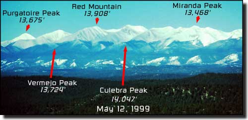
While I was driving through the amazingly empty southern Colorado/northern New Mexico area on my awesome trip a few weeks ago, I got curious about the mountains to the west of I-25. It's an interesting ecological area, the border region between the Chihuahuan Desert, the high plains, and the Rockies, and among those empty mountains are 14ers and dinosaur tracks.
You've never heard of any of these; they're kinda sorta the Front Range of the Rockies but way down in southern CO, called the Sangre de Cristo Mountains. From Sangres.com.
Turns out the army is trying to expand their little-known base there, and in a familiar theme, the local private landowners, ranchers, environmentalists, and outdoors types recognize they actually all have a common interest to work together. The story here is a fascinating (and useful one) on multiple levels. Here's the Summitpost entry for one of those peaks (Culebra), some of which are privately owned - but accessible thanks to the owners.
After a scouting trip to the desert, I decided to take a pass on my brilliant idea of running the Algodones Dunes from I-8 to 78.
Running this for 22 miles? No thank you sir.
That's actually one on of my worse ideas,
which is saying something. Even driving it like these guys would suck.
As if to emphasize the point that this is a blighted land, while we were passing through nearby Brawley on the way to the Blythe Intaglios, the Earth delivered up some nice earthquakes. The timing couldn't have been better. I had to put down the coffee I was preparing and ran out of the convenience store. I went back in to finish it and another one hit.
But a bad idea that I still think is good is the San Diego coastal relay! 78 miles, 10 runners. Who's in? Main problem to solve, running along the shipyards and whatnot along the east side of San Diego Bay would be much less pleasant than running along the Silver Strand, but how to cross over from OB/Point Loma to Coronado - add a kayak leg?
So I survived the three months of my surgery rotation only by imagining the promise of the San Juan Mountains in my future, and what a promise it was. Somehow all my wanderings around the Western U.S. had not taken me to them, and last week with trusty pal Dorothy I finally set off to correct this. Interestingly, my neglect of the San Juans and CO Rockies generally seems to be shared by my fellow Californians - we noticed a dearth of CA plates, but no shortage of TX, OK and KS.
The route, which was every bit as awesome as it looks:
(Geek point: to figure out the best trip, I prioritized what I wanted to
do, then used an online Traveling Salesman solver and added nodes
sequentially, seeing where there were significant jumps in travel time.
Not surprisingly, there was a jump in travel time for paying my respects to Caballo Blanco by going for a run in Gila Natl Forest or going to the Oklahoma Panhandle just because. I will definitely be planning future roadtrips this way.)
You will notice on that route a visit to Flagstaff, a cool town that people are unfortunately finally discovering; Wupatki Ruins (including the ball court and wind cave that I forgot about) and finally entered the Navajo Nation, which I seem unable to permanently escape. There we saw easily the most amazing rainbow of our lives. We stopped for the obligatory fry bread and passed through Monument Valley and Mexican Hat. Notes: don't eat fry bread with honey while driving. Monument Valley is oddly unsettling at dusk. Mexican Hat has a little restaurant (the Olde Bridge Grill) with great lamb dishes overlooking the San Juan River near the famous goosenecks. And finally: the Four Corners area does in fact close at night. But eff 'em because it's not really the Four Corners anyway.
Wupatki Ruins, north of Flagstaff.
A ball-court at Wupatki.
A double-rainbow in Navajo Nation.
We seemed to be driving into the base of it for 30 minutes.
I didn't ask what does it mean.
From there we passed through Cortez on the way to Durango. We decided not to go back to Mesa Verde and Hovenweep Natl Monument. Cool though they are, especially the coded steps, my travel companion told me that where she's from there are thousand-year-old dwellings all over the place so she wasn't so impressed anyway.
Durango bills itself as a Four Corners-area town but SW Colorado is the outgroup of the four states that come together in that region. Because it's higher it's greener; Durango just looks different. Once arriving in Durango we recognized that it apparently has a law that only awesome things are allowed to be there. The mountains and trails around it are of course spectacular, plus there are brewpubs and fun restaurants, plus there's a hiking train (!) plus just randomly one day there was a plane taking off with a glider in tow right next to town. Even the flea market is awesome (see the scorpion-lamp below):
Scorpion Lamp by Ron Howell. Check out bracelets, lamps and more here.
He's a cool guy and he only makes dragon and scorpion stuff. Ron doesn't screw around.
The only downside is that my Jeep Liberty kicked the bucket in February and there were a number of trails we couldn't get to without a 4WD. It's not like California dirt roads (i.e. getting to Holy Jim Falls and Santiago Peak in the Trabuco Unit of Cleveland NF) - when Coloradans say 4WD-only, they're serious. The first day: Engineer Peak, starting at Coal Bank Pass. Every day we got chased by thunder. In California we don't usually have this problem, but in Colorado every year people are killed by lightning. Lesson from this trip: when hiking Colorado peaks in the summer, start early. Early early early!
Famous image of a woman on a mountain observation deck.
Lightning struck within minutes of this picture being taken, badly injuring her. Don't put yourself in this position in CO in the summer, start early!
Post-glacial kettle-pond On the way to Engineer Peak.
A rock glacier on the north side of Engineer.
Landscape with sasquatch.
The area north of Durango, around Silverton where we did most of our San Juan explorage.
Afterward we headed into Silverton, a town which I absolutely fell in love with. Why am I so smitten by this struggling mining town full of eccentrics?
- It's full of eccentrics.
- At over 9,000', only Leadville is higher.
- It has its own 100 miler (the Hardrock 100), most recently won by Hal Koerner. (Go there for photos if for no other reason.)
- Of course it's surrounded by amazing hikes and climbs.
- As if to lure me in, the first business I walked into (an old Victorian Hotel) was showing Blade Runner, my favorite movie of all time. (Actually it kind of spooked me. Reminds me of that one bit from Bradbury's Martian Chronicles.)
- Finally, this tiny town has not one by two restaurants that serve Rocky Mountain Oysters. (More later.) One such establishment helped me trick my travel companion with a Jackalope, while serving us Durango Brewing Company's excellent blueberry beer. (Does anyone know where we can get this in CA?!?!)
Rocky Mountain Oysters, which we euphemistically called "nuts". Someone (not me) insisted on coming back a second night in a row for these, so delicious did she find them the first time -
which led to me on subsequent evenings to sleep uneasily in a protective position.
The next day, still in the San Juans, we headed up to Ice Lake, which may have been my favorite of the trip.
If you told me the world was created starting from this place, I might not be surprised.
It was during this hike that my companion advanced her controversial theory that people of Germanic descent enjoy and are better at trail-running and hiking in temperate or boreal forest because we are after all a post-glacial forest people. My counterargument to her: say no to drugs.
This fellow was insultingly relaxed.
As in, he actually relaxed at us seemingly to prove a point.
The lake was pretty cool, so we took some video, although we dared not dawdle due to the hail and thunder. Don't ask me what those people were doing camping up there.
We also took video of a less-relaxed marmot who lived by the lake and who was telling us what's what.
The next day we went up to Ouray (pronounced by locals "yeRAY" - people in Denver, take it up with them, not with me), where we hiked to the Bridge of Heaven. Not as high as the area around Silverton and a little drier - this was actually in Uncompahgre National Forest. Ouray is where much of the original True Grit was filmed. It was also the inspiration for Galt's Gulch in Ayn Rand's Atlas Shrugged, although there was no solid gold dollar sign hanging over the valley. (I did once see one near Cholame, CA once, but that's another story.) A great brewpub, real live cowboys, and of course more trails. Ouray seems to have developed better than Silverton.
I was sure glad to get above the gritty urban hustle and bustle of Ouray. (Above, lower right.)
The camera didn't believe how green these trees were.
I took a couple videos getting up near the top. When I was coming back down I decided to record a little bit of the run (sorry for the Blair Witch motion-sickness-prone among you). I had to stop and tie my shoe so as not to take the fast way back down to Ouray.
After we came back down we chillaxed by the car at the stream and looked at trees and clouds, after which time we headed up to Montrose.
Before leaving the San Juans, a geography note: Shotgun Peak in Rio Grande Natl Forest in the southeastern side of the San Juans looks very strange geologically. See all those valleys east-southeast of the msa? If you run across this article searching or by a news alert, and you have some clue, drop a comment - I'm curious as heck what's going on there.
Things change when you get north of Ridgway. You're out of the San Juans, and it gets very dry and flat and you feel like you're in New Mexico or Utah. Black Canyon of the Gunnison is there, and it is, as one hotelier put it, "Well...it's a big canyon." If you're in the area see it, but I wouldn't go out of my way.
It is at this point you will notice a dearth of (good quality) pictures - because Dorothy lost her phone at the Mt. Elbert Trailhead (if you see it email me! LOL!). The upside is that there are few pictures of me with a beard, which she made me grow. The only record is me at the summit, which a nice fellow on top took and sent to me.
So I've bagged the #1 and #2 peaks in the lower 48. SWEET. I also saw a pika during the climb, way above the tree or even the grass-line. We ended up racing back down as dark clouds gathered. Why? Thunder. Start early!
From there, we headed to Boulder to see friends Dave and Jacqui. It was really good to catch up with them (thanks guys) and good to experience some actual heat. On the way from Elbert to Boulder we realized we'd never hike all the NFs in Colorado. For that matter I still haven't been to Rocky Mountain Natl Park! But Dave took me on a nice run up the Flatirons right next to Boulder.
This is the knife that cut Joe Simpson's rope - i.e. the guy from Touching the Void.
In Neptune Mountaineering in Boulder.
From there, someone was too good to drive back to San Diego, so I took the Princess to DIA, leaving poor me all by my lonesome. Actually there was cool stuff on the way back. I finally got to drive up to Pike's Peak (wanted to see how the car did at 14,000'; would've run but no time); checked out the Garden of the Gods (red rocks below); and then drove the amazingly empty strentch of I-25 from the Springs to Santa Fe. There are two things out there, Jack and Sh*t, and a whole lot of 'em at that.
A special note on Santa Fe: what a cool little town. Again, somehow I'd passed by or quickly through this place in the past, in retrospect to my detriment. The old town and Plaza Mayor are gorgeous and Maria's New Mexico Kitchen is in the coolest little-big adobe with the tastiest food ever.
A church door in Santa Fe's old town.
It was damn hot south of Albuquerque even at night, so I shouldn't have been so surprised to see that sidewinder crawling across the highway in my headlights. Sorry guy.
At daybreak I got off the highway at Socorro to head over to the Very Large Array (VLA), a radiotelescope installation I've been obsessed with for a while. If you've seen Contact or 2010 or Terminator Salvation, you've seen the VLA.
This was a wall of post-it notes from visitors who wanted to leave messages for the astronomers who run the place. Below: this was my own helpful note, after having seen Terminator Salvation. But I think I was too late because the place was completely unmanned. I didn't see a single person the whole time I was there, even in the (open) visitor center.
Originally after the VLA I was going to head down to Gila NF to pay my respects to the late Caballo Blanco, but there had just been a fire there and it's out of the way anyway; I'll get there some other time. I'm not sad since I ended up being amazed by the greenness of western NM/eastern AZ at this time of year. This is probably the most surprised I've ever been by the way a part of the U.S. looks. They also have cool (weird) names for towns. Right after this one, I went through Omega also.
After that I paid a visit to the Mogollon Rim in Sitgreaves Natl Forest, Arizona. It was so green that there was a fern-filled valley in one place (sorry, no pics) and plenty of awesome trails; I got in one last run on my last day.
Above: the Mogollon Rim is that green stripe. It's the southwestern edge of the Colorado Plateau. The running was fantastic but pretty hot (90 F) even at 7500'; then again, let's not get carried away complaining since after all it was Arizona in August.
During the run I saw a fire starting on a distant peak, which by the time I was getting out of the Natl Forest toward Mesa had blossomed into a full-on fire. There was dry lightning all around.
The way back included normal Phoenix traffic, the endless emptiness of I-8 west of Phoenix, a sandstorm in Yuma, the fires in the mountains here, and almost hitting a flying owl on I-8. It was like a fantasy novel or something. I fought the demon horde, then crossed the Empty Quarter, survived the smothering sands, then braved the land of fire and darkness. One does not simply drive into Mordor.)
Yuma. It might actually look better when you can't see it.
Imagine all that grit in your teeth, which is what happens when you have to get out to pump gas.
Coming up the east side of the Peninsular Range on I-8. The fires to the left (from my vantage point, south in the range, in Mexico) were much bigger than what remained of the San Diego County fires at that point, although they were less reported here. The sunset they produced was spectacular.
This trip was a blast and was exactly what I needed to unwind after surgery. Thanks to Dave and Jacqui for putting us up/putting up with us on Friday night, Jason for hiking tips, and Dorothy for being the best road trip buddy EVAR!
[Added later for your enjoyment if you travel in the area as well as my own later consultation:
Solvitur ambulando! Note the thick brow-ridge and the death-grip on the beverage. You can email this handsome devil at mdcblogs@gmail.com. "[If you are depressed] go for a long walk...and if still depressed, then walk again." -Hippocrates ca. 410 BCE
SUPPORT YOUR BLOGGER
Donate? If you enjoy and find useful what you read here, any little bit helps and is appreciated!
Rattlesnake Encounter Map
Have you run across one of our scaly friends on a trail in California? Take 5 seconds and add it to this map so we can see where interactions are more likely to take place, and make life safer for trail users.


 Famous image of a woman on a mountain observation deck.


