Saturday, January 7, 2017

Running the Schuylkill River, Part I

In the next visit after the one I describe below I finished the rest of Berks County, and you can read about this impressive and death-defying feat here.


The ultimate destination.
Image from the Constitutional Walking Tour website.

My goal in writing this up is to get more people to use the Schuylkill River Trail in Berks County (of which Thun Trail is one part.) In 2015 it was named the best urban trail in America. You should really check out the Schuylkill River Trail website, which maps the whole length of it all the way down to Philly. Originally my plan was to run the whole length of the river through Berks County while I was there over the holiday. But as of right now the SRT is only complete in pieces, and many of the country roads in northern Berks are really not safe to be running on for many miles at a time. So here I'm only describing from the confluence of the Tulpehocken to the Montgomery County line. (I ran around Blue Marsh and ran down to the confluence with the Schuylkill as well in another of my many ludicrous running projects.)

It's worth mentioning that the SRT in Berks would be an ideal location for a volkmarch. In Germany, people will set aside a day when you along with friends and family walk to a village in your valley a few miles away, have a pint in the inn there, then get up and walk another few miles to the next village...and repeat. Sounds like a blast, right? What's stopping us Dutchmen from continuing this tradition? And this trail is perfect for it! I picture it starting on a late spring day at Victor Emmanuel or Trooper Thorne, then stopping at Ridgewood Winery and the Fork and Ale...that would be a fun day. But until then...on with the River!

From the Schuylkill River Trail website,
where you can click on the subsections

READING SECTION
I started at the confluence with the Tulpehocken because of my Blue Marsh project. From there, it's on the road a little to the Route 183/Schuylkill Avenue Bridge. From here to RACC was easily my least favorite part of the run. Trash on the trail, vandalized signage, and total desertion even at 3pm on a warm winter day did not make me want to dawdle (plus the trail is obstructed where there is construction under the Buttonwood Street Bridge is under construction). At RACC things start looking up again. The converted pedestrian bridge across the river affords a vantage point I've never seen from the bypass. On the other side is an unpleasant but not terribly unsafe-feeling industrial area; then you're on the overpass right across from Queen City. There's a little 19th century graveyard right there which I never knew was there, despite driving right past it a thousand times when I lived in Reading. You're then running along 422, and there's an abandoned stone booth with some interesting graffiti; suddenly you're behind UGI and then Victor Emmanuel's (who seem dead set on stopping anyone on a public trail from hopping the fence to come to their restaurant. In the summer this would be awesome!) The Brentwood Trailhead on the Thun Trail (a Berks portion of the SRT) is just past that.


Above: there's an oddly placed iron rail bridge near RACC that used to be on top of a (now filled-in) canal.


Above: Reading skyline from RACC. All my pictures were taken in late December.


Above: on the pedestrian bridge over the river. An interesting angle on the city you've probably never seen before.


Above: a little grim northeast industrial winter. Would be good for a metal album cover.


Above: graveyard between Route 10 and 422 near Queen City.
The oldest marker I saw dated to 1822.


READING OUTSKIRTS/CUMRU
From Brentwood, you quickly feel isolated (in a good scenic way) running along the river with Neversink to your left. In a few miles you come to a much higher, longer rail-to-trail bridge (this is the highlight of this section for me) and pass the old Titas generating station on your right. You cross under 176, and then cross 724 on foot. Ridgewood Winery is just southeast of here, and the newly-opened Gibraltar Hill State Forest, which has unexpected views of the Schuylkill River Valley and Neversink across the way, is up Ridgeway Road to your right here.


Going over the Schuylkill on the Thun. Image credit to user DWill320 at Panaramio.


ROBESON TOWNSHIP
The trail continues for a few more miles along the base of Gibraltar Hill, at the edge of fields until you reach Gibraltar. Nearby route 568 between 724 and Route 10 might be my favorite driving road in all of Berks. From Gibraltar you're on roads for a few miles, so be careful. The first is Old River Road - not heavy traffic, fairly straight so you can see what's coming, and enough lawn/shoulder so you can get out of the way. Very pleasant, lots of small houses and fields. Then you cross 724 (be careful) and you're now on Schuylkill Road, right next to the river. I liked this bit.

BIRDSBORO
Once you get to Birdsboro proper, you cross 724 one last time before picking up an actual trail again. This takes you right to Union Township Recreation Area, which has bathrooms (and the Fork and Ale is right there as well).


Above: bamboo stand between Morlatton Village and the Berks-Montgomery County line. Below: a friend I met on the trail near Birdsboro.


DOUGLASSVILLE AND POINTS BEYOND...
From here the trail is all rail-to-trail straight down to the Montgomery County Line - nothing really that special but a very pleasant flat jaunt through the woods next to the river. There is actually an official campsite along this stretch, and another converted bridge that's kind of neat. I saw plenty of people accessing the trail from Douglassville, and there's official access at Morlatton Village (oldest building in Berks). You pass under River Bridge Road and 422, and then there are two large stands of bamboo which struck me as odd. Finally you pass the small sign marking the Berks-Montgomery border, and arrive at the County Line parking area. There are a couple more miles of trail at this writing, but it ends in Pottstown. While you're in this area you might also want to check out Monocacy Hill, which has volcanic rock at the top.

Remaining sections for the future: Phoenixville to just past the Art Museum has been built so I'll start working on that next time I'm in PA. There are all kinds of other cool trails constantly being finished too like the Perkiomen, which meets the Schuylkill in Valley Forge. And of course up through the heart of Pennsylvania Dutch country, to the gap in the Blue Ridge where the Schuylkill emerges into Hamburg from the Coal Regions...which also happens to be where the Appalachian Trail crosses it. Another project?...

I Ran Around Blue Marsh


In all seriousness, Blue Marsh has the best single track in Berks. (Map at bottom.) Unlike the PA AT, it's not so rocky as to be super-annoying, and it's beautiful, constantly affording unexpected views. (There's the Blue Ridge right through that gap in the hills...and hey, there's the Pagoda...and when you get tired of the woods, we're right next to Spring Ridge and a great Vietnamese restaurant and a Wawa! One could ask for nothing more in life!) Downsides, in fall these trails are heavily subscribed by hunters (so wear your orange) and in winter those trails have a habit of retaining ice when it's melted elsewhere. Christmas Eve this year was misty and cold but Christmas Day was beautiful. The full trail is 30 miles around the lake, which the maniacs who do the Blues Cruise do all at once. This of course has been another of my ridiculous running projects (see my Schuylkill River Trail project here), I'm still waiting for someone to give me a cookie for doing them.


What a difference 2 months makes.


For my money, by far the most scenic section of the trail around Blue Marsh is the one that runs from the cliff at the end of Lake Road in Heidelberg Township, then down the western side of the lake; definitely the most isolated and hilly. (It was also a 55-degree blue sky Christmas Day so maybe I was influenced by that.) Out toward the end of the peninsula that Skinner's Loop is on, on the south side, it looks like there's another cliff (but if you jump off of it you will definitely 100% die. So don't. Now you can't sue me.) There were also a bunch of seagulls sitting out on the ice and the most interesting critter I saw during the winter was a woodpecker, although during the warm October day when I was there before there were an enormous amount of spittlebugs doing their thing in the fields. Mostly it's very well-marked but there are lots of unofficial trails and a few of them still don't have clear signage. I also went for an unanticipated half-mile run on the beach on Christmas Eve near the Visitor Center. All in all, I really think Blue Marsh is an underappreciated resource.


Above: the wife standing at the top of the cliff on an 80-degree October day. Below: the same spot ten weeks later. I can't believe I used to just jump off this damn thing.


From the Blue Marsh Visitors Center it's a very pleasant 8 or 9 miles along the old canal to the confluence of the Tulpehocken and Scuylkill, downhill to Rebers Bridge Road, then under 222 to the covered bridge and the Distelfink, past Grings Mill and the lockhouse and ultimately through Stonecliff Park. The confluence area isn't particularly pleasant, but it was the beginning of my Schuylkill River run (see more here.)


Above: Der Distelfink along the Tulpehocken (credit Berks County), and below, a bird sculpture along a trail on Lantau Island, Hong Kong. (This suspicious resemblance was noted by your blogger, who, having discovered this perfidy, is mounting a lawsuit to defend our Dutchy intellectual property, sparse as it is.)


Above: the entrance to the underworld, which not surprisingly is in Bern Township


Full-size map that you can actually use to plan available at bluescruiseultra.com

Wednesday, January 4, 2017

Rose Bowl 2017


It was highest scoring game in the history of the Bowl (in fact, that was already true by the third quarter) as well as the coldest. In fact it felt and looked very much like a mid-to-late October day in Pennsylvania (plus a stiff North Pacific breeze), which I would've thought favored us more. Despite the heartbreaking last-5-seconds loss, it was a great season, an exciting game, and USC's fans are pretty solid as fans go - one held onto and returned a dropped wallet for someone in our group, and the between-fans conversations I heard in the food lines were always pretty civilized. Give me a Pac-12 fan over an SEC fan any day! Pre-game festivities shown below with the stadium in the background.


The Verdugo Hills (above, image credit summitpost) are right next to where we stayed in Burbank, and I've long wanted to get a run in along the spine of the ridge. I've been curious about this area ever since seeing them from across the way in Griffith Park (by the way, one of the most underrated urban parks in the country). They're just far enough from San Diego that when I lived down there they weren't worth driving to for their own sake, but I would always see them on the way to the Angeles NF and wonder. Once again, the schedule didn't allow and like Penn State's bowl win, it wasn't to be. (UPDATE: I did eventually get a run in there and they're pretty cool.)


Verdugo hills trail map, from the City of Glendale (legible version here). I was going to use hikespeak.com to plan my run.


As an aside, my late father was about the most insane Penn State football fan there was, and went to many bowl games - and every one he went to, Penn State lost. People used to jokingly tell him to stay away from the bowls, and when I worked out the odds I saw that he had a 1.3% chance of seeing only losses. So I went to the Rose Bowl, my first as an adult, partly to see if this phenomenon is genetic. It appears to be!


Above: DNA, along with equations and people seriously comparing things on a clipboard, have confirmed that the Penn State Bowl Game curse that runs in the K10 family is in fact genetic.


Sunday, January 1, 2017

US State and County High Points

I'm starting to track the high points I've been to. Oddly it was going to Pennsylvania's high point that made me start doing this. Interested readers, should they exist, will no doubt want to point me to the online organizations that track country, state and county high points. I love reading about people that do this officially, but I'm not registered on those sites.

To further deflate the significance of the enterprise, it must also be said that it's silly to make a list of hills and mountains that is highly dependent on the territorial whims of the primates scrambling about their flanks at that moment. While the likes of Whitney and Elbert have some claim to being on any such list, Ebright is certainly on here only because of its good luck that on the day colonial Pennsylvania's Lower Counties asked the king for home-rule, he was in a good mood. Much more importantly, altitude is only very indirectly related to difficulty of climbing, difficulty of climate, mortality risk, and most critically, natural beauty and enjoyment of the experience, which is why we all do this in the first place. But read my list anyway.


National high points: I have none as yet, and will not be getting one for my own country's Denali (McKinley to Lower-48ers), because I've declared I will never attempt it. I did attempt Mexico's Orizaba but the altitude got me.


State high points I've been to:

CaliforniaMt. Whitney, 14,496' (highest in lower 48)
ColoradoMt. Elbert, 14,440' (second highest in lower 48)
OregonMt. Hood, 11,230'
South DakotaBlack Elk Peak (fmr. Harney), 7,244'
North CarolinaMt. Mitchell, 6,684'
New YorkMt. Marcy, 5,344'
PennsylvaniaMt. Davis, 3,213'
DelawareEbright Azimuth, 448'


High points I care about and may at some point go out of my way to get to:
Washington (fourth highest in lower 48)
Hawaii (highest in the world if you count from the Earth's crust, but no one does except patriotic Hawaiians)
Montana
Wyoming
Utah
New Mexico
Arizona
Missouri
Arkansas


California county high points I've been to:
InyoMt. Whitney, 14,496'
TulareMt. Whitney, 14,496'
SiskiyouMt. Shasta, 14,162'
San BernardinoMt. San Gorgonio, 11,499'
RiversideMt. San Jacinto, 10,839'
Los AngelesMt. San Antonio (Baldy), 10,064'
ColusaSnow Mountain, 7,056'
LakeSnow Mountain, 7,056'
OrangeSantiago Peak, 5,687'
NapaMt. St. Helena, 4,200'
Contra CostaMt. Diablo, 3,849'
AlamedaRose Peak, 3,842'
SolanoMt. Vaca, 2,819'
MarinMt. Tamalpais, 2,576'
SutterSouth Butte, 2,120'
San FranciscoMt. Davidson, 925'
SacramentoCarpenter Benchmark, 828'*

*Behind private property barrier by about 100', but I count this one because screw them


I was interested to learn that I have not yet been to the high points of Santa Cruz or San Mateo Counties (I thought I had). Besides those, I also care about Fresno County's (higher than Shasta), and the ones in the coastal counties, except for San Diego, which is privately owned and I'm not going to pay dammit. Also, like many I have long dreamed of making it to the high point of Berks County, Pennsylvania, which is on the Appalachian Trail...perhaps one day!

State Tripoints: Two Down, One To Go [Update: Three Down, One To Go]

[Note: because I'm so cool I now also have the Austria-Slovakia-Hungary tripoint - see here. Oh you think that's an obscure tripoint? Probably because you don't have it, as a result of not being as cool as me. But hey. That's alright. Not many people are.]

There are many state tripoints, but a) I only care about the ones around Pennsylvania and California (seven) and b) even of those seven, four of them are in water.

The ones that are in the water are:

California-Arizona-Nevada (Colorado River)
Pennsylvania-New Jersey-New York (Delaware River)
Pennsylvania-West Virginia-Ohio (Ohio River)
Pennsylvania-New York-Canada (Lake Erie)


Of the remaining three, I've made it to two of them:

Pennsylvania-Maryland-West Virginia (done October 2016)
Pennsylvania-Maryland-Delaware (done December 2016)
California-Oregon-Nevada [edit: done June 2024]

Since I've been to the two tripoints including PA and MD, that means I've been to both ends of the Mason-Dixon line. According to noted geography expert my wife, that has only been accomplished by two other people in history: Mason, and Dixon. So now you have to call it the Mason-Dixon-MDK10 line. (I'm a humble man so I volunteer to make my name last.)

[Edit: Pennsylvania-New York-New Jersey, goddammit is on land. ONE MORE as of June 2024.]


PA-MD-WV:


PA-MD-DE:


[Added later due to coolness] Austria-Slovakia-Hungary

The Conquest of Ebright Azimuth


(Here is my slightly more serious list of actual meaningful high points.)

Dear readers, before your very eyes shall unfurl a tale of such danger, such daring, and such triumph, that will AMAZE YOU!

Heretofore unknown except in myth and ancient texts of dubious provenance, Ebright Azimuth - the highest point not just in Newcastle County but in all of Delaware - is pictured here.


There are those who think that our conquest of Mt. Davis, highest mountain in Pennsylvania, has filled us with hubris. Nonsense, we say! (Not to mention poppycock and hufflepuffery, which I will exclude from the present proceedings that we may preserve the virtues not just of ladies - but of gentlemen.) Below you can see (at top) the route preferred by less skilled explorers. But we not only assaulted the fortress of heaven at night, we pioneered a new route!


Above: the traditional routes up Ebright. Below: our innovative though admittedly risky approach. Never one to blanche in the face of danger, we forged on!


And the jagged soaring peak mounted by your blogger is - THE SAME. I blame you not for your disbelief, which is why we have captured the moment of elation as we stood in reverie of highest aerie, on this selfsame photographical plate.


We purchased supplies and victuals from a temple of the goose known to the locals as "Wawa", performing the required ritual ablutions. Then we set out and with the native guides we'd hired, we pushed ever upward into the merciless gale. They averted their gaze from the peak, speaking only in hushed tones as we crossed glaciers under the full moon, fearful of angering the spirits of wind and stone with their insolence. For man does not belong in these places, and I must admit when my eye would alight high up upon the terrible promontory of our final destination, I too would share an urge to hurl myself at the ground and grovel for my life, and I cannot entirely fault them for their superstitions. Though those from the villages on the plateau at the base of this range are surely of a hearty and hale race - for they must be - still, we lost three men to frostbite and hypoxia. Not without reason, for the air is so thin at the top you can see stars, and we had to duck when the international space station hurtled past.

Is there no corner of this world, no matter how foreboding, how inaccessible to man, safe from the penetrance of your bloggers' steely determination? NO I SAY!

Friday, October 28, 2016

Cool Stuff in Berks County, Pennsylvania

[Added later: great collection of Berks County nature links here.]

For going on two decades I've been a Californian, but I emerged into this world in old Berks. And when you move, you change quickly. First the leafless winter forests start to look shockingly barren, and then people start to sound (and think) funny, and then it just doesn't feel like you belong there anymore. But since I've grown into my foreignness, I've been able to see Berks with new eyes, and I now really enjoy visiting as a tourist. The almost tropical green canopy of a Pennsylvania forest in summer, the dusting of snow around an old stone house, windows glowing warmly next to a stubbled field - these are things you don't see in California. I can also appreciate as well that Pennsylvania is one of the most culturally and historically unique parts of this country, but of course both visitors and residents of Berks might point out that cultural uniqueness doesn't give you anything to do - it's not an event. I kind of did convert culture into an event last year by literally stumbling across John Updike's grave in Plowville last year, although I'll grant that grave-stumbling is not something you can plan.

So without further ado, here's my list, which is just as much to advertise Berks as it is for me to revisit when I'm back home. (If you want the full on promotional experience, you can go to visitpaamericana.com, which is actually a pretty good resource.)

CREATORS:[Added later, why didn't I think of this before?] writer John Updike, artist Keith Haring, and musician Taylor Swift (or is that "musician"? depending on your taste).

PROXIMITY TO NATURE AND THE URBAN NORTHEAST: it's cliche, but in Berks you're close to many other things, without paying big city prices. There are not a lot of other places in the country that can say this. In particular, do NOT underrate the opportunities in the Appalachians - the Appalachian Trail, Glen Onoko Falls (and here are my photos), Ricketts Glenn, and a million other forests and parks and gamelands. Do you ever get up to State College? Do you get out on the mountain trails every time? Why not!?? (When I was in college I did, and I still don't think I did it enough.) A friend from California who spent his childhood summers in Yosemite said that he thinks the Delaware Water Gap is the prettiest place he's ever been (it sure has more bald eagles than Yosemite). And of course there are day trips to New York and DC and the shore in the summer. (I kick myself for not going to New York, Philly and DC more before I moved away.)

BERKS OUTDOORS: good in ANY season. The way I used to think, winter put a stop to any outdoor activities. But if you live in the West (including California) it's just a time to do a whole other set of activities. Get those boots on, the silence and purity of a winter hike is amazing!

- Remember, the Appalachian Trail - which from Hamburg you can take to the Pinnacle, and from 183 you can take to the highest point in Berks.

- Blue Marsh and Tulpehocken Trail - every time I'm home I'm just amazed how pretty this lake is (and since I ran around the whole thing I'm something of an authority on the matter.) And in the summer, the Rock in Hamburg may be closed, but the Cliff in Bernville is not. Of course there's an ultramarathon if you want to do it all at once and have people hand you water along the way. (Actually a lot of good races like this in the area.) Also remember Gring's Mill and the Canal Museum!

- Mt. Neversink - cool trails from near 422. Looking down at the Schuylkill there it almost reminds me of parts of Oregon; the view actually makes it feel isolated.

- Mt. Penn - VERY cool trails and even some ruins.

- French Creek - an oddly under-discussed park, and there is more and more land connecting to it, making the contiguous conserved area much bigger, i.e. Hopewell Woods, and now Gibraltar Hill, which is now open. (Views from the top are excellent.) Also odd in that these low hills are so steep - at one time they were probably the highest mountains on Earth, hundreds of millions of years ago. True story, French Creek is the only place I've heard an extended first-language conversation in Pennsylvania Dutch.

- Nolde Forest - as a kid I used to think it only served the function of lame destination for field trips, but I really enjoy running there now. After all, one New York Marathon winner trained there...

- Schuylkill River Trail - already pretty cool, with signage from Hamburg down to Reading, and then with rare exception connected all the way to Philly (and already connects almost continuously from Philly up to Pottstown.) Needless to say I'm going to be through-running this whole thing too.

- Pretty drives - I spent my teen years driving around the back roads of Green Hills and often comment that Napa is the closest thing California has in terms of rural scenery. And that Fleetwood-Lyons/State/Main/Weis road parallel to 222 up in the northern part of the county is also very pretty.


HISTORY: there are preserved canals (in Gibraltar and Wyomissing), and Routes 724 and 10 were both already used as wagon paths in the mid 1700s. Route 61 was used as a footpath by Unami-speakers for who knows how many centuries!

- The AME church in Reading - not only the sixth AME church in the U.S., but a place used to smuggle slaves on the underground railroad, with the preserved underground chamber still viewable. The late Frank Gilyard was kind enough to give me a tour.

- Homesteads - Conrad Weiser, Daniel Boone, Morlatton (oldest building in Berks), Hopewell, and nearby Ephrata.


FOOD: first, it must be said, there really is nothing like Wawa, or for that matter Sheetz, anywhere else in the country. Berks has great Italian and PA Dutch food and I've found some fun night life too. And in a half hour you're in Lancaster with all the smorgasbords, buggies and shoofly pies you could ask.

- Mom Chaffee's in West Reading - great Italian

- Mangia in Mohnton - get the cheese wheel (thanks Dan)

- Chatty Monk and Winedown - is it just me, or did Penn Avenue in West Reading get a lot more interesting in the last ten years? Vertigo Records was a fun find too.

- Hong Thanh - in the Weis plaza in Spring Township, one of my favorite Vietnamese places anywhere, even including the West Coast.

- Beer - Goggle Works has the best beer selection of any place I've been in Berks (although if you're reading this and know of more, I'd be happy to be proven wrong). And Stoudt's brewery is just down in Adamstown.

- Ridgewood Winery - I haven't yet been but I love that there's a winery right there.

- Mike's Tavern near CarTech - the crowd is one of the more interesting mixes I've seen in a while, I'll be getting in there when I can.

Tuesday, October 25, 2016

Pennsylvania, October 2016

The usual nonsense. (Lots of stuff just in Berks County outside of Philly, go here for a list.)

PHILLY
We hit Pat's Steaks the night we landed, but I'm still a Jim's guy. On the way into the hinterlands I visited the oldest building in Berks County, built by Swedes who had ventured up the Schuylkill to build the first stone structure (Morlatton House ca. 1716), three decades after William Penn's ride up the icebound river to negotiate with the locals. Daniel Boone would be born not quite 20 years later a couple miles further up the road. My inevitable surprise in Berks County though is Blue Marsh, whose prettiness somehow still shocks me. Also, I"m now so old that I an't remember how to find the Cliff without looking online. I did a very nice 6-miler just from the Cliff to the Heidelberg Bridge in Bernsville, and needless to say I can't just enjoy it for what it is so next time I have to run around the thing.


Above: online map courtesy Blues Cruise Ultra.
Below: Blue Marsh and trails.


STATE COLLEGE AND CENTRAL PENNSYLVANIA
I wasn't nearly the trail maniac in college that I am today and regret that I didn't spend more time exploring Central PA (Allegheny National Forest for one thing.) It was fun getting to State College but it's been long enough that I'm quite ambivalent about these visits and in truth I'm not even nostalgic anymore, since PSU doesn't feel like it's "mine". I knew this was very likely my last visit and it was a nice swansong. I got into the Rathskeller for a beer in honor of my dad. I foolishly didn't drink in college so, oddly enough for an old alum saying goodbye, this college staple was actually a novel experience for me. (Worry not dear reader, I stopped that nonsense and now I drink quite heavily.)


After the obligatory crowded post-game-day hike up Mt. Nittany, we headed down to the area between Huntingdon and Mt. Union to bag the Thousand Steps. Also very busy! A part of the nifty Standing Stone Trail, I've had this one on my bucket list for a while. I recently became obsessed with the Allegheny Front and Plateau, and noted how north of the PA Turnpike, the escarpment gets steeper as it ascends rather than rounding off as the ridges to the east do. The boundary between Alleghenies and Ridge-and-Valley in PA is also the watershed boundary between the Atlantic and Gulf of Mexico. There is very little conserved land right along the front and this is a fascinating and unique area of Pennsylvania and the Northeast generally.


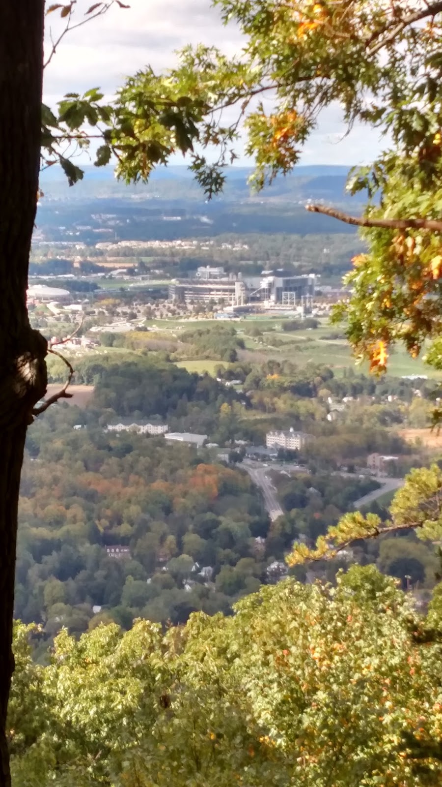
Above and below: view from Mt. Nittany; second is zoomed on Beaver Stadium. I never learned if it was really true that every seat facing Mt. Nittany had to be able to see it. (By the way, did you know they already had the Nittany Lion in Tang dynasty China? See if you can find it in the photos here.)


Above: hey THANKS.
Below: view from the top of the Thousand Steps.


Above: you don't have to be a geologist to see the Allegheny-Ridge and Valley boundary here. The Turnpike climbs onto the Plateau between Bedford and Somerset, fittingly enough where you pass through the Allegheny Tunnel. The Flight 93 site is nearby (already been) and there's a cave in nearby Mann's Choice with coral fossils from the Paleozoic but dammit it's privately owned and hardly ever open.


Above: the Allegheny Front (in red) is also the boundary for central PA dialects, not unexpected as people's travel would historically be impeded there, and the differing geology has probably led to different economic activity. Nice illustration of the principle that geological barriers obstruct both gene and meme flow. Below: another box checked: view from the top of Mt. Davis, the highest point in Pennsyvania, at 3,213'. Yes, lower than Foresthill. But still neat and felt very plateau-y.


SOUTHWEST PENNSYLVANIA

Another point! The PA-MD-WV tripoint! I'd previously seen Fort Necessity (where young George Washington learned the value of guerilla warfare from the French), Wright's Fallingwater, and Ohiopyle rapids, and my travel companion was satisfied merely hearing the eloquent orations I delivered on these and many other topics during the drive. Unknown to me until this visit: a few miles from Fallingwater is Kentuck Knob, another Wright home. (And very unpatriotic of me to say, I saw a restored Qing Dynasty official's home in Chengdu, Sichuan, China, that I thought was much cooler than Fallingwater; scroll down here for some pics.) For a while I have been scheming to run up Mt. Summit, the face of Chestnut Ridge, the very last of the Allegheny-Appalachian system as one heads from the East Coast into the Midwest - but there is no safe way to do it. Yes, the local club holds a race once a year where (I verified) they run up the highway - not safe! - and there's a road that comes up the back way right past where Washington (or his native ally) killed the French officer Jumonville that sparked the Seven Years War (or the true first world war, depending who you ask). Either way, also not safe.


Above: your blogger at the tripoint. In the background are West Virginia border guards, who scrutinized our entry papers closely, and then ate them. Below: Mt. Summit Hotel at the top of Chestnut Ridge, the edge of the Alleghenies, looking west over the start of the plains. Washington's French-killing spot is about three miles from here.


Above: supposedly the steepest street in the U.S., Canton Avenue. Below: to the extent that the Whiskey Rebellion had a headquarters, this was it. George Washington just could not stay out of Western Pennsylvania to save his life.


Above: Pittsburgh and the start of the Ohio River. Note the sediment coming from the Monongahela. Below: looking down the Duquesne Incline tracks back toward the river. Again you can see the sediment boundary from the Mon River.


Other silly PA projects for the future:
- Laurel Highlands Trail
- Standing Stone Trail (Thousand Steps is part of it)
- Ascent of the Allegheny Front (route 30)
- PA-MD-DE tripoint (the only other one in PA that's not underwater)